Saturday, September 5, 2020

Crater Lake during Covid 19


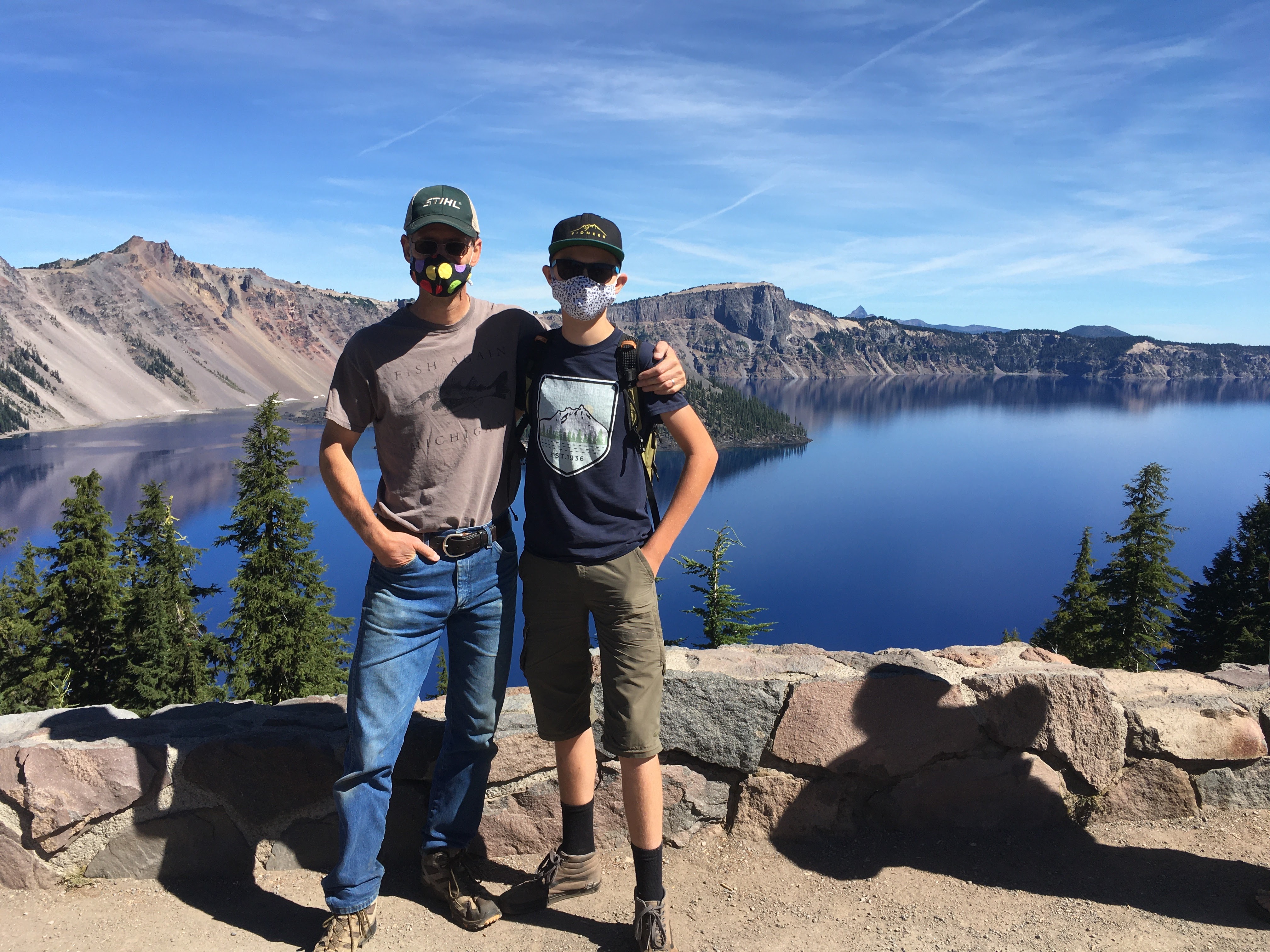
We traveled to Crater Lake during July of 2020. A lot of the National Park services were closed, including the ferry to Wizard Island. However, there were many visitors - the majority wearing masks. 

My husband and son (along with about 200 others) jumped into the lake.


We also wanted to cycle around the lake, but found that it was going to be too dangerous. So, we opted to drive behind our son while he road down the longest hills between overlooks. I think his fastest speed was about 35 mph.


Thursday, September 8, 2016

Deschutes River and Historical Museum

We took a quick trip to Bend and were able to walk along the Deschutes River and also visit the Deschutes Historical Museum. The museum is a quick visit, but well worth it. I would definitely not stay at the Riverside Inn in Bend. We had a pretty bad experience there.


One the way home, we also stopped at Detroit Lake to explore the dam and eat lunch.


It seems like the water level was higher compared to August last year. 


Friday, October 9, 2015

Jackson Bottom Wetlands


The most beautiful place in my own habitat is Jackson Bottom Wetlands. The natural area never fails to inspire.


Wednesday, June 24, 2015

Steens Mountain

We traveled to the Steens Mountain mid-June. Our first plan was to camp at Paige Springs, but the mosquitoes were rampant. We ended up camping at Fish Lake on the mountain. At Fish Lake, the mosquitoes were about a week behind Paige Springs and the temperature was about 10 degrees Fahrenheit cooler. The wildflowers were out in full force.


The gate at Jackman Park was opened the day we arrived. We are able to drive to the top and see Wildhorse Lake, the Alvord Desert, and Keiger Gorge. 


We did very little hiking, but the boys swam and fished in Fish Lake. We also visited Fields and Diamond. 


Tuesday, March 31, 2015

Fort Rock


Fort Rock is a highly accessible and beautiful rock formation the middle of high desert country. The volcanic formation sits to the northwest of Christmas Valley. The formation is designated a natural area and is managed as a state park. You can visit dawn to dusk. There is a restroom, some picnic tables and a park host.

The park is surrounded by hay farms, and, hence, a variety of ground squirrels, jack-rabbits and other small mammals. The rodent population attracts large birds of prey - some of whom nest at Fort Rock. We spotted a newly deceased Great Horned Owl below what appeared to be a cliff-side nest. Perches have been added to electrical poles in the area. Along the highway, we spotted a bald eagle, golden eagle, and a ferruginous hawk.Circling close to Fort Rock were prairie falcons, vultures, and raven.

The entire rock formation can be hiked within a few hours. There were several highlights for us. We enjoyed yelling across the formation and hearing our voices echo back. The rock itself is pretty interesting - with a variety of vesicles forming patterns in different section of rock. If you walk close to the rock, it is possible to find several locations where owls drop pellets and thousands of small bones. Walking to the top of Fort Rock, you will be able to peer over the sheer outer rock face. The rock itself has a hollow sound to it when you knock on it.

On our hike, we spotted a few lizards, birds, and jack-rabbits. It also looks like prime rattlesnake habitat.

If you want to camp in the area, north of Fort Rock about five miles is the Cabin Creek Campground - a rough camping area. The campground offers a beautiful Ponderosa pine forest - but not water or toilets. At the south side of the campground are some Forest Service buildings and two bird blinds. We spotted nut-hatches, nutcrackers, mountain bluebirds, and chickadees. We also heard flickers. The mammal population seemed hopping - lots signs (tracks, scat and sound) of deer, elk, coyotes and bobcat. We did not see any mammals, though.


Thursday, May 8, 2014

Sunstone Mining - the Sequel


In March, we headed back to the Dust Devil Mine to see if what we could dig up. This time, we brought one of my son's grandmothers...and lunch. We were prepared to give our son as much time as he wanted to find as many sunstones as he could.

Unfortunately, in the spring, the mine does not supply tools.  My husband had a maul in his car toolbox, and this kept my son busy for quite a while. Grandma and I worked with shovels and a shaker table. We found quite a few stones. My son, however, had was determined to dissect a 24-inch diameter boulder. He could see a large stone on one face.

Henry worked on this for about an hour when the man who was watching over the facility showed up and began to give him some good advice on how to delicately pull the boulder apart. He also retrieved his five-pound hammer and the chisel from a jackhammer. The boulder was pretty quickly reduced to many smaller rocks.

By the time the boulder was apart, Henry had a bucket full of specimens (rocks with sunstones not yet removed) and sunstones. Some of the sunstones were fairly large. We spent quite a bit for the stones (more than the market value), but it was worth the expense for the experience.

I asked Henry this morning if there was any sort of an adventure he would like to go on this summer. He wants to return to the sunstone mine.

Friday, April 11, 2014

Hiking the hills in Lakeview


Lakeview, Oregon is a small town (~2,500 residents) in the south, central part of the state. It sits at a mile in elevation and is high desert. From the hills in Lakeview, you can see Goose Lake straddling the border of Oregon and California.


Every decade, high school students repaint the letter 'L' in the hill-side near town. The hike to the 'L' is steep and fairly rocky but short (~ 0.5-1 mile each way). It is a great opportunity to spot deer and wildflowers (in the spring).

This year, our hikes in the hills were unique in the view of the shockingly low water level of Goose Lake (in March). Everywhere we went, people in the area had something to say about the drought. It will be a tough year for cattle as well as the native animals and migrating birds.

Thursday, April 10, 2014

Crack In the Ground

Crack in the Ground is a geological site in Christmas Valley, Oregon.  It is a two-mile long rock-lined crack in the ground (up to 70 feet deep and 10 feet wide).  It is possible to hike in the bottom of a short section of the crack with limited bouldering.

We walked in the bottom of the crack and returned by walking on the top. The canyon itself s interesting – the walls on one side of the crack are smooth and weathered with rounded surfaces. The other side has sharp edges and rock planes. The Wikipedia site on this location indicates that Crack in the Ground is a volcanic fissure. It is believed to be fairly new – only ~1,000 years old.

The most interesting part about the location was the top-side return hike. First, it would be possible to be on horse-back in this area and fall right into either the main crack or one of the tributaries.  There is no real indication that at crack exists as you make a perpendicular approach.

We also observed a large nest sitting on the top of one of the larger rock surfaces in the crack with three tan eggs. It might have been an owl’s nest that had been abandoned. Cliff swallows were also present.


This is an easy hike and the overall visit could last from 1 – 2 hours. We were pretty hungry and headed into Paisley for a late lunch.

Friday, March 28, 2014

Derrick Cave – Fort Rock, Oregon

Derrick Cave is a large lava tube, located in south-central Oregon. The cave is best accessed from the north. Original access was described as part of the BLM’s Back Country Byway. However, this route requires crossing private land. The current landowners appear to have had enough bad experiences with people not understanding how to drive on rocky, gravel roads. Signs posted at the start of their property warn that there is no longer access to Derrick Cave from the south. A good forest service map of the Newberry National Monument will lead you to the cave.

Derrick Cave is unique in both its size (30-foot diameter) and use as a nuclear fall-out shelter during the Cold War. At one time, the cave was outfitted to provide food and water for approximately 1,200 people.

Our visit to Derrick Cave was the first ‘caving’ experience for me and my son. It was a great way to start our caving adventures. The cave is big enough that we were able to stand throughout. The hiking involved a bit of scrabbling across boulders. The biggest adjustment was hiking in the dark. We had some fun with periodically turning all of our lights off.

We brought a few head lamps, flashlights and our usual first aid kit and water. We spent about an hour hiking into and out of the cave. Because it was spring, the outside temperature was not much different from the interior of the cave. However, in the summer, the temperature difference would be large. There are ice formations in the cave. There was also quite a bit of dust. The surfaces of the rocks are abrasive – so long sleeves, gloves and good shoes (i.e. not flip-flops) are a good idea. I walked out with torn gloves, but my running shoes were fine.

Tuesday, June 18, 2013

Dust Devil Mining - Digging for Sunstones

The Oregon gemstone is the sunstone - a plagioclase feldspar - containing copper shiller. A designated public sunstone collection area is found in the Rabbit Basin to the northwest of the Hart Mountain Antelope Refuge.

We have a family interest in rocks and have enjoyed looking for thundereggs at Richardson Rock Ranch in Madras and fossils in Fossil. We visited Dust Devil Mining to collect sunstones. The people at Dust Devil Mining were really helpful and led us through all of the ways to find sunstones. The mine included options to  dig, rake, sift and pick rocks apart - looking for sunstones. This is a terrific activity for youngsters. The rocks are easy to find.

Wednesday, June 12, 2013

Hart Mountain National Antelope Refuge


South of Steens Mountain is Hart Mountain National Antelope Refuge. Hart Mountain is a fault block ridge contained within a 422 square mile refuge. The refuge is predominantly high desert but also contains a large wetland area at the base of the mountain.

We camped one night, hiked a bit near the campground (Hot Springs Campground) and took advantage of a natural hot spring surrounded by low man-made walls. The campground was soggy and probably a better fit for a camp trailer. While camping, we managed to spot several small groups of pronghorn antelope and a herd of bighorn sheep.

On our way out of the refuge, we hiked around Petroglyph Lake. The west side of the lake is rimmed by basalt boulders. The basalt was carved over 10,000 years ago by some of the people living in the area. We were able to spot at least 10 petroglyphs, many of animals. We hiked back to the car on the top of the rim. A variety of desert wildflowers were in bloom. We also spotted what seemed to be intentional circular arrangements of rocks.

If we were to visit Hart Mountain again, we would like to explore more of the refuge and hike to the top of the mountain (~8,000 feet). The refuge is fairly isolated. It is important to have water and emergency supplies. The road to Petroglyph Lake was a bit of a challenge for the car and this appears to be true of the majority of roads in the refuge.


Steens Mountain

We took a day trip to Steens Mountain, driving up to the Fish Lake campground. Fish Lake is 7,400 feet above sea level. The road to Fish Lake had opened a week or so before our trip and the area still had several inches of snow. On May 29, the road was open as far as Jackman Park.

At Fish Lake, the guys spent some time fishing and I did some birdwatching. In spite of the cold temperatures and snow, the tree swallows were picking up insects hatching from the lake. The dog enjoyed trying to track down the frequent and briefly appearing squeaky rodents.

If we were able to travel to the Steens later in the year (August), our goal would be to drive the Steens Mountain Loop road, hike down to Mann Lake, visit the Riddle Brother Ranch and check out Kiger Gorge.

Friday, June 7, 2013

Visting the Malheur National Wildlife Refuge

We recently traveled to south central Oregon to explore the Malheur National Wildlife Refuge, Steens Mountain, Hart Mountain National Antelope Refuge and the Sunstone Public Collection Area. The trip required quite a bit of planning for a variety of weather conditions.

The Malheur National Wildlife Refuge encompasses approximately 187,000 acres of land, including the largest lake in the state, Malheur Lake, and a large amount of wetland and meadow. The refuge is part of the Pacific Flyway and is a great place to see birds nesting or pausing during their migrations.

The refuge begins about 30 miles south of Burns, about a 6-hour drive from Portland. A good place to begin a visit to the refuge is the Refuge Headquarters, on Sodhouse Lane on the south side of Malheur Lake. The Refuge Headquarters has a lot of information about the refuge (a driving tour, a list of birds and mammals and a list of hikes). In addition, if you are not an experienced bird-watcher, the museum has a lot of birds on display.

There are places to stop and view birds throughout the refuge. There are also a few hikes, some good places to fish and one of the nicest campgrounds I have ever been too (Page Springs) at the south end of the refuge in Frenchglen.

If you can make a trip, you probably need at least 2 or 3 days at the refuge. In addition to an abudance of bird watching opportunities. There are some good hikes, promising fishing locations and historical sites. The historical sites are predominantly part of Peter French's ranching operation. If you have even more time, you could visit and hike around the Diamond Craters Outstanding Natural Area.

We spent 2.5 days at the refuge. This was about right for our 8-year old son. In May, be prepared for rain and cold. The rain was torrential and we were lucky to have a sturdy tent to hold up to the wind. We went ahead and explored the refuge, the historical sites and completed a strenuous 6.5 mile hike along the Blitzen River - the only time we came across a rattlesnake. To give ourselves a chance to dry out, we also ate out a few times.

There are a few restaurants: The Narrows at the north end of the refuge, the Frenchglen Hotel and the all-in-one grocery, gas and restaurant in Fields (with excellent milkshakes).

Thursday, July 7, 2011

Sheep Rock

Sheep Rock in the John Day Fossil Monument is located in a valley along with a section of the John Day River. The stratified hills in the area reveal the entire mammal history. The site also contains the primary visitor center for the monument. The visitor center has a nice museum containing examples of the fossils found in the hills. A paleontology center is actively used for cleaning and preparing fossils for study. If you have time, you might be able to take a guided ranger tour.

This is a nice stopping point for our son. The center has a lot to explore and there are hiking trails fairly close by. Across the street from the visitors center is the Cant Ranch House - the historical home of one of the original ranching families.

Down the road in Dayville, the Fish House and RV park is a terrific place to spend the night. You can camp, stay in your RV or rent rooms. Dayville also has a few markets and a gas station.

Friday, June 17, 2011

John Day Fossil Monument

The monument is about a four hour drive from Portland. There are three primary sties: Clarno, Sheep Rock and Painted Hills. All of the sites are worth a visit.

Clarno is the site of the fossilized nut beds and mammals. It is adjacent to the Hancock Station (an OMSI educational facility). There are a few short hikes at the Clarno site and the scenery is dominated by basalt palisades.

If you can, joining any of the OMSI programs at Hancock Station will enable you to see much more of the Clarno area than the monument facility will. OMSI offers access to the digging sites.

We enjoyed the hikes and the picnic area. The best part of our visit was speaking with one of the employees of the monument. He was knowledgeable of the area in a way that helped us to make sense of what we were seeing and  very passionate about the history or the flora and fauna. In general, any time we speak to some of the older employees at the national parks and monuments, we have a really great experience.

Bring water, food, any park documentation you can find and wear long pants. The terrain is comfortable for rattlesnakes.

Thursday, June 9, 2011

Oregon Rocks

We just returned from a trip to the John Day Fossil Beds Monument. The monument is located in the north-central part of the state of Oregon; about a 5-hour drive from Portland. We like to visit this location because:

- it is a beautiful part of Oregon
- there are not many people
- we like fossils and rocks

On the way out, we stopped in Madras at the Richardson Rock Ranch to hunt and dig for thundereggs. The ranch is quite large (of 20 square miles) and has been in the family for 7 generations. In addition to cattle ranching, the Richardson family allows people to hunt for a variety of rocks. They also sell rocks from around the world.

At first, we had no idea what we were doing. We drove to an area set-up for digging and pulled out our gloves, eye protection and borrowed rock hammers (provided at the ranch). The gloves and eye protection were great to have. Towels and water would have been good, too. Digging was a dusty process.

A knowledgable fellow showed up with his family and helped us to better understand what we were looking for. Thundereggs can have ridges on the outside that indicate the formation of a central agate region that is usually fairly crystalline in appearance. There are also mudballs that contain a lot of small round nodules on the outside and a fairly dense, dark center.  We picked up about 10 pounds of rocks - mostly thundereggs, but also a piece of obsidian and some rose quartz.

We will have to go to the Rice Museum and see if we can have the thundereggs cut open.

In terms of a family event - this was a great way to go. We could have spent the entire day at the ranch - especially if we had brought a lunch. There are several digging sites and the store and museum of interesting. Our son's imagination was running free while we were digging. He formed a rock-hounding partnership with another little boy and they were busy the entire time.

It would be helpful to do some research beforehand to know more about what to look for.

Friday, May 27, 2011

Dye Sensitized Solar Cell Mimics Nature

When I think of solar cells, I usually think of blue panels with thin metal lines patterned on the surface. These are crystalline silicon cells - the most common in industry. Commercial silicon solar cells are ~15% efficient.

There are about ten different solar cell designs that seem to have commercial potential. One approach that I am really interested in learning more about is the dye-sensitive solar cell.


I am still trying to learn more about why this cell works so well in ambient light. I hope to track down some of the journal articles.

Titanium dioxide is the conductive matrix in the cell. It is a common enough compound (in toothpaste, for example). In these cells, however, it is formed as a nanostructure sponge.


The scientists behind the dye-sensitized cell indicate that the cell mimics photosynthesis in the way that charge is shuttled through a redox reaction.

Saturday, May 14, 2011

Garden - one big science project

We are going through the process of planting a garden for grown-ups this year. In years past, I have planted a chaotic garden where I allow every volunteer that sprouts to remain in place. We end up with quite a bit to eat, but have had problems with fungus, insects, and various worm-like creatures eating their way through everything.

This year, my husband widened the garden to enable his restored 1940's era rototiller to fit between rows. The garden has four 44-foot long rows. He also purchased a pallet of aged chicken manure and spread it on the garden. I was hoping to burn off any residual fungus in from last year. I am working from Square Foot Gardening and A Householder's Guide to the Universe to figure out how much to plant and where.

We bought our seeds and strawberry starts from Territorial Seed. Why? Well, because the company is fairly local (as is the autheor of the Householder book). It is difficult to really know when to plant in Portland, Oregon. We have heavy, wet soil and often misleading periods of warmth.

Other factors we have already contended with: the dog (she loves the chicken manure), squirrels (I think they ate the lettuce and dig up seeds) and birds (same as squirrels).

The hypothesis for our big project is that by actually weeding and properly spacing out the plants this year, we will have a higher yield and less problems with garden pests. Unknowns: we had some stink bugs show up last year, the weather is colder and wetter than usual and our work schedules might interfere with all of the obligatory weeding.

Saturday, May 7, 2011

Forming Expressions in Geometry

I tutor math once a week for a fifth grade Spanish immersion class in a local public elementary school. This week, we worked on calculating the area of a triangle. The students had a variety of triangles to work with - most not right triangles.

In general, geometry has been more interesting to the students than the other topics we have worked on (multiplication, fractions and decimals). The challenge this week, though, was to figure out how to write the area of the triangle as an expression (i.e. A = 1/2bh). For one, the students are not comfortable multiplying by 1/2. They would rather divide by 2. I believe that this is the first experience for the class with algebraic expressions. For these students, even assigning different letters for the base and height (instead of b and h) was bewildering.

I also find it really interesting to see the combined challenge of language (the students I work with often do not have a strong handle on English - and we work in English if the main lesson is in English) and learning math concepts. Sometimes it is difficult assess why a student does not understand a concept, or even if they understand but cannot find the words.

Sunday, May 1, 2011

Hands-on in MT102

I teach an introductory course on semiconductor devices and am never sure of the backgrounds of my students. I thought it might be helpful if we completed some hands-on activities that would demonstrate some of the class principles.

Experiment 1: What conducts?
This was a simple experiment to help students see a closed-loop circuit and to explore what materials will conduct.
Supplies:


  • Battery (D-cell, AA)

  • Battery holder

  • Test leads with alligator clips

  • Low voltage buzzer (my collection came from Radio Shack)

  • Random samples (pencil, aluminum foil, conductive dough, mylar film)

Students built a circuit to make the buzzer sound and then tried adding one of the samples to the loop.


The experiment went well. Students were surprised that the mylar film did not conduct but looks like it is metallic.


Experiment 2: Measure the resistivity.


Supplies:


  • Conductive dough

  • Multimeter

  • Ruler

I gave the students blocks of conductive dough and had them measure the dough with the ruler. Then then measured the resistance of the dough using the multimeter. A simple conversion:


R = resistivity * l/A


enables the students to determine the resistivity. The students then varied the geometry of the dough to see if the resistivity value was the same.


This experiment was not as successful. The dough does not have a static resistivity. I think it might be because the dough uses salt for conduction - so is really somewhat of an electrolyte.


I also had the non-conductive dough (which conducted for some reason - I had added food coloring, this might be the problem) and this seemed to be more stable.


Experiment 3: Measure the approximate band-gap energy of an LED


Supplies:


  • 2 AA-batteries

  • Potentiometer

  • Leads with alligator clips

  • Multimeter

  • LEDs of various colors (clear housings)

The students created a circuit with the batteries, potentiometer and LED. They measured the voltage across the LED as they varied the potentiometer - watching for the point at which the LED lit. They repeated this going up to the point of the LED turning on and going down to the point of the LED turning off. The voltage measured is approximately an measure of the band-gap energy (eV).


This experiment went well. The students were able to make the measurement and see some variation in the the band-gap energy with the wavelength of light emission. This was good practice for orienting diodes in circuits.


Experiment 4: Measure the I-V characteristics of a pn-diode


We did this experiment before I introduced the I-V curve.


Supplies:


  • AA or D-cell battery

  • Test leads with alligator clips

  • Potentiometer

  • Diode

  • 2 Multimeters

The students built a circuit with the battery and diode. They placed one multimeter in series with the diode, and set the multimeter to measure current. The other multimeter was placed across the diode and set to measure voltage. As the potentiometer was turned, they recorded voltage and current a few times.


We combined everyone's data and generated an I-V curve for the diode. I am not sure how this experiment went. I will know more at the next class.